Climate Change Allowances for Flood Risk Assessments
When you prepare a Flood Risk Assessment, you're not just assessing flood risk as it is today. You're assessing it over the lifetime of the development, and that means accounting for a changing climate. Climate change allowances for flood risk assessments are the percentage uplifts the Environment Agency expects you to apply to river flows and rainfall so your design holds up decades from now. They're not optional extras: for most sites in or near a flood risk area, getting these allowances right is central to whether the FRA and the drainage design will be accepted. This page explains what they are, which ones apply, and how they feed through into design.
What climate change allowances are and why they're required
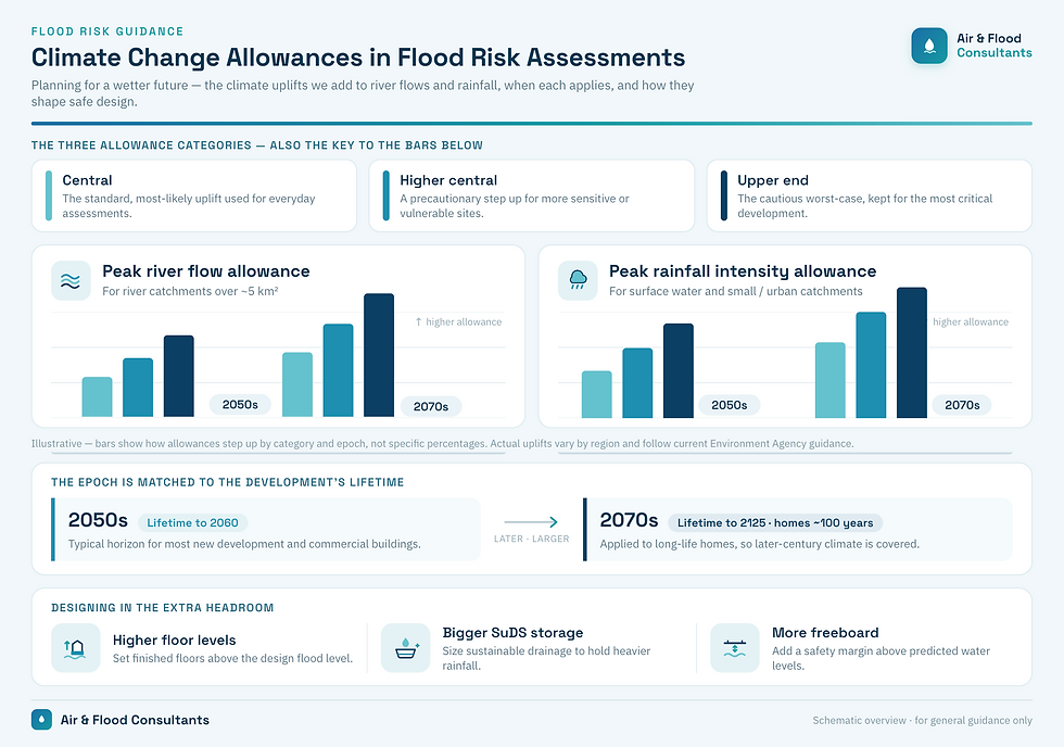
A climate change allowance is a percentage by which a baseline figure — a peak river flow or a peak rainfall intensity — is increased to represent likely future conditions. The science is uncertain, so rather than a single prediction, the Environment Agency publishes ranges of allowances and asks you to choose appropriately for the type of development and its lifetime.
The requirement flows from national policy. The NPPF expects development to be safe over its lifetime, taking account of climate change, and the Planning Practice Guidance points to the Environment Agency's published allowances as the basis for doing so. The EA frames all of this through its guidance, "Flood risk assessments: climate change allowances", which is the document you should be working from. The allowances feed both flood risk assessment and drainage design, so they matter as much to your SuDS strategy as to the flood risk assessment itself.
The two main types of allowance
There are two distinct families of allowance, and which one matters depends on how your site floods.

Peak river flow allowances
**Peak river flow allowances** apply to fluvial (river) flooding. They increase the modelled peak flow in a watercourse to reflect a wetter, more extreme future. These allowances are most relevant to larger rural catchments — broadly those above around 5 km² — where river flow is the dominant flood mechanism.
They're published by **management catchment** and **river basin district**, because the projected effect of climate change varies geographically across the country. So the first step is to identify which management catchment your site sits in, then read off the appropriate allowance for that area.

Peak rainfall intensity allowances
**Peak rainfall intensity allowances** apply to surface water (pluvial) flooding and to drainage design. They increase the intensity of design rainfall events. These are the allowances that matter most for small and urban catchments — broadly those below around 5 km² — and for the surface water drainage systems and SuDS you're designing on site.
If you're sizing attenuation storage or checking that a development won't flood from surface water, peak rainfall allowances are the ones doing the work. Like river flow allowances, they're given by river basin district and as percentage uplifts.

Time horizons: the 2050s and 2070s epochs
Allowances are tied to time periods, known as epochs, because the further into the future you look, the larger the expected change. For most development the two relevant epochs are the **2050s** and the **2070s**.
The choice between them comes down to the lifetime of your development:
- The **2050s allowance** is generally used where the development has a lifetime up to **2060** — for example, many commercial buildings, which are often assessed over a shorter period.
- The **2070s allowance** is used where the lifetime extends to **2125** — which covers residential development, generally assessed over a lifetime of around **100 years**.
So a typical housing scheme will usually be tested against the 2070s allowances, while a shorter-life commercial unit might reasonably use the 2050s. The development's design life, not just its type, is what determines the epoch, and you should justify the lifetime you've assumed in the FRA.
.webp)
Allowance categories and sensitivity testing
For each epoch, the Environment Agency publishes more than one allowance, reflecting the range of plausible futures. You'll commonly encounter:
- **Central** — the central estimate.
- **Higher central** — a more precautionary figure.
- **Upper end** — the most precautionary, representing a higher-impact scenario.
Choosing the right category isn't a free choice; it depends on the flood zone, the vulnerability of the development and the level of risk that's acceptable. In many cases the EA expects you to design to one allowance and then carry out a **sensitivity test** using a higher allowance, to check what happens if climate change turns out to be worse than the central estimate. If a development still performs acceptably, or fails gracefully, under the higher allowance, that's a much stronger planning case than a design tested against a single figure.
For more vulnerable development in higher-risk locations, the precautionary categories tend to apply as the design case rather than just the sensitivity check. The FRA should set out clearly which allowance has been used as the design value, which has been used for sensitivity, and why.

How allowances flow through into design
Allowances aren't an academic exercise; they change the physical design of the scheme. The main routes are:
- **Higher finished floor levels.** A larger peak river flow allowance raises the design flood level, which in turn raises the finished floor level you need (typically with freeboard on top), influencing the whole ground-floor design.
- **Larger SuDS attenuation storage.** A higher peak rainfall allowance means more runoff to hold back during a storm, so attenuation tanks, basins or ponds get bigger. This can have a real effect on site layout and cost, which is why it's worth establishing early.
- **Freeboard and safety margins.** Allowances interact with freeboard. The climate change uplift is built into the design flood level, and freeboard is then added above that, so the two together set the level the development must sit above or be protected to.
Because these effects ripple through levels, drainage and layout, the sensible time to pin down the allowances is at the start of the design, not after the architecture is fixed. Retrofitting a larger attenuation pond or higher floor levels late in the process is expensive and disruptive.

Use the current published figures
One practical but important point: the Environment Agency **updates these allowances periodically** as the climate projections are revised. The figures have changed more than once over the years, and they vary by region, so there's no single number to memorise. You must always work from the **current published allowances** for the relevant river basin district and management catchment at the time of your assessment. An FRA built on superseded figures is an easy one for a consultee to reject, and we always check the live guidance before finalising any assessment.

Get in Touch
Applying climate change allowances correctly takes knowing which catchment you're in, which epoch fits the development's lifetime, and which category the EA will expect for your site. We do that day in, day out.
Get in touch to discuss your site and receive a quote.
.webp)