Groundwater Flood Risk Map: Check Your Site
Rivers and surface water get all the attention, but some of the most stubborn flooding in England comes from below. Our groundwater flood risk map screens any site in England and places it in one of four classes — High, Medium, Low or Negligible — using national geology, terrain and groundwater level data. It answers the question the Environment Agency's flood map can't: is groundwater a risk at this site? This page explains what the map shows, what each class means for you, and what to do if your site doesn't come back green.
Why groundwater flooding doesn't appear on the flood map
The Environment Agency's "Flood map for planning" covers rivers and the sea, and its surface water map covers rainfall ponding and overland flow. Neither shows groundwater. A property can sit comfortably in Flood Zone 1 and still flood from below when the water table rises after a wet winter — it happened across the Chalk of southern England in 2000/01, in the record wet winter of 2013/14, and again after the storms of 2023/24.
Groundwater flooding is slower and quieter than river flooding. It arrives weeks after the rain that caused it, it can last for months, and it finds basements, cellars and below-ground services first. The British Geological Survey estimates that hundreds of thousands of properties in England are at risk from groundwater alone — most of their owners have no idea, because no free national map tells them.

What the groundwater flood risk map shows
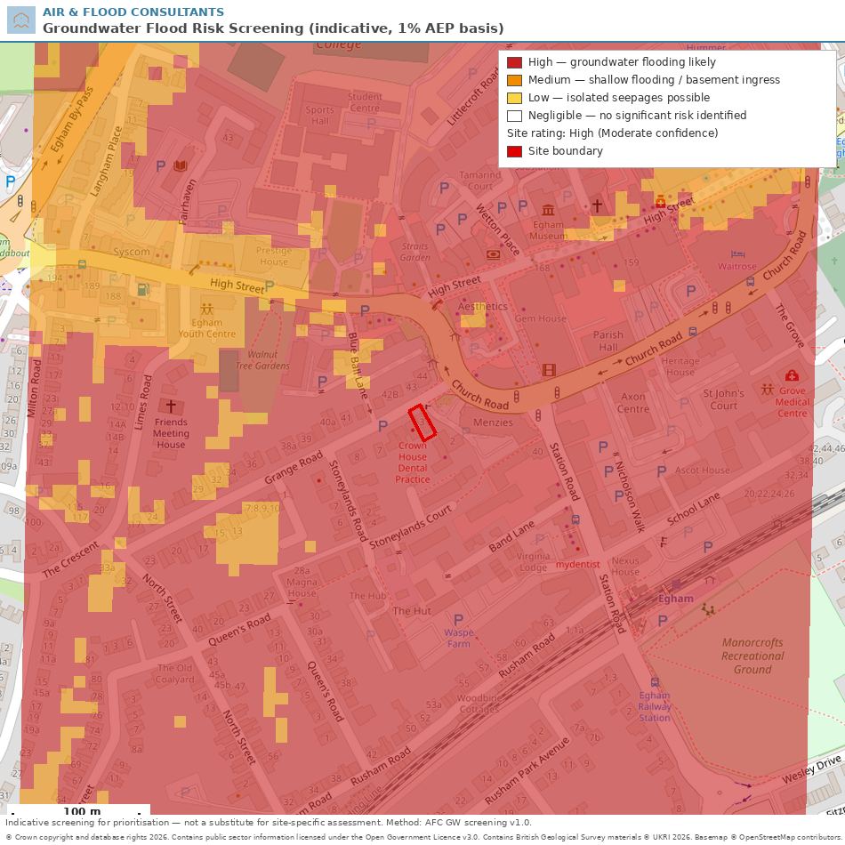
Our screening model builds a groundwater risk picture for your specific site and its surroundings, then assigns one of four classes. The classes combine likelihood, severity and confidence, in line with the conventions used by national groundwater datasets:
- **High Risk** — groundwater flooding is likely. Damage to property and infrastructure possible.
- **Medium Risk** — shallow flooding and basement ingress likely during high groundwater levels.
- **Low Risk** — isolated seepages may occur. Consideration advised for sensitive developments.
- **Negligible Risk** — no significant risk identified, though localised features may differ.
The result comes as a colour-banded map of your site and the surrounding streets, plus an evidence summary: the geology under your site, nearby borehole records and water strikes, groundwater monitoring data and any recorded groundwater flooding nearby.

How we check groundwater flood risk
The screening draws on the same families of national data used by the established commercial groundwater maps: Ordnance Survey terrain data, Environment Agency LiDAR ground levels, British Geological Survey 1:50,000 geological mapping, and groundwater level records from Environment Agency monitoring boreholes and BGS borehole archives — including digitised water strikes from real ground investigations near your site. Where groundwater flooding has been recorded nearby in the Environment Agency's historic flood records, that evidence is folded in too.
What makes the difference is geology. Chalk, limestone and sandstone areas can flood when the water table itself rises above the valley floor. River gravels — much of London's Thames corridor — flood when high river levels push groundwater up through the permeable ground behind the defences. Clay areas, by contrast, usually screen out as Negligible. If you want the full technical detail, our groundwater flood risk model methodology page sets out every dataset, threshold and limitation.

What each result means for you
**Negligible** — no groundwater-specific action needed for most projects. Standard good practice still applies for anything below ground.
**Low** — groundwater sits within reach of deep foundations, soakaways and basements. If you're planning a [basement](/basement-impact-assessment) or infiltration drainage, check seasonal levels before you design.
**Medium** — basements and below-ground structures need proper waterproofing design (BS 8102) and usually groundwater monitoring. Planning authorities in groundwater-prone boroughs will expect the risk to be addressed in your [flood risk assessment](/floodrisk).
**High** — groundwater flooding is a realistic prospect. Expect your planning authority to require a site-specific [groundwater flood risk assessment](/groundwater-flood-risk-assessment), and design below-ground elements defensively from day one.
An important honesty note: this is an indicative screening tool. It is designed to prioritise sites for further assessment, not to replace a site-specific investigation. A High result doesn't mean your cellar will flood next winter, and a Negligible result isn't a guarantee — local features like springs, old field drains and made ground can behave differently.
Is there a free map of groundwater flood risk?
There's no free national groundwater flood map in England — the Environment Agency's public maps cover rivers, sea and surface water only. Detailed groundwater maps exist but are commercial products. We provide a site-specific screening as part of our flood risk work, which tells you the class at your site and the evidence behind it.

How do I know if my house is at risk of groundwater flooding?
Warning signs include a history of water in cellars or under floors, springs and winterbournes nearby, chalk or gravel geology, and neighbours who pump their basements in wet winters. The reliable answer is a screening against geology, terrain and groundwater records — exactly what our map provides.

Does groundwater flooding affect insurance?
It can. Groundwater damage is treated differently by different insurers, and cover for gradual seepage is commonly excluded. Knowing your risk class — and being able to show mitigation — puts you in a stronger position with insurers and buyers alike.

I'm planning a basement. What depth to groundwater is a problem?
As a rule of thumb, groundwater within about 2 metres of the surface is a live design issue for basements, and anything within 5 metres deserves attention for deeper structures and drainage. Between those depths the answer depends on geology and season — which is why Medium and Low results recommend monitoring before design.

Get in Touch
Send us your site address or a boundary plan and we'll screen it — the groundwater risk class, the map, and the evidence behind it, explained in plain English. If the screening flags a risk, we'll tell you exactly what your planning application needs and quote a fixed fee for the full groundwater flood risk assessment.
Get in touch to discuss your site and receive a quote.
.webp)