SuDS Infiltration Potential Map: Check Your Site
Every drainage strategy in England starts with the same question: can this site soak away its own rainwater? Planning policy puts infiltration at the top of the drainage hierarchy — soakaways and permeable paving before tanks, tanks before sewers — and your local flood authority will expect evidence either way. Our SuDS infiltration potential map screens any site in England and places it in one of three classes — High, Moderate or Low — using geology, soils, borehole records and groundwater levels for your specific site. This page explains what the map shows, what each class means for your project, and what to do before anyone digs a trial pit.
Why infiltration comes first
National planning policy and the SuDS standards ask developers to deal with rainfall as close to where it lands as possible. Infiltration into the ground is the preferred route: it mimics natural drainage, it takes load off overwhelmed sewers, and it doesn't increase flood risk downstream. Lead Local Flood Authorities now routinely condition planning approvals on a drainage strategy that either uses infiltration or demonstrates properly why it can't.
That demonstration is where money gets wasted. Infiltration testing to BRE 365 means excavating trial pits, filling them from a bowser, and timing the fall — typically over three repeat runs. Commissioning that on a clay site is an expensive way to learn what a desk screening would have told you for a fraction of the cost. Equally, ruling out soakaways by assumption on a gravel site throws away the cheapest, most planner-friendly drainage solution available. Screening first means you test only where testing makes sense.

What the infiltration potential map shows
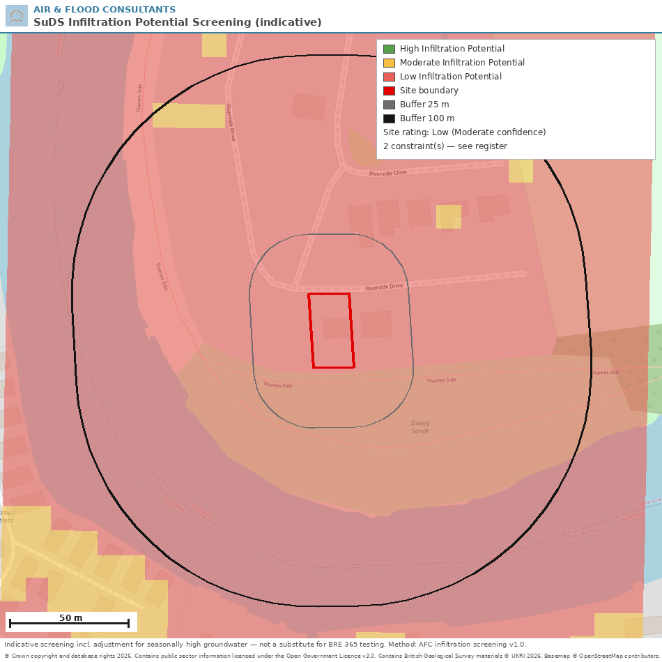
The screening classifies your site and the surrounding streets into three classes, using the same class language as the established national infiltration suitability maps:
-
High Infiltration Potential — the ground is expected to be permeable enough for free-draining SuDS, with groundwater sufficiently deep. Soakage testing confirms the design rate.
-
Moderate Infiltration Potential — infiltration may well work, but something needs proving first: variable ground, seasonally high groundwater, a thin receiving layer or made ground.
-
Low Infiltration Potential — infiltration is unlikely to be the primary answer; plan for attenuation with a controlled discharge, and keep small-scale infiltration for water quality.
Alongside the class, you get something the national maps don't provide: a constraint register for your site. Source Protection Zones, nearby landfills, made ground, steep slopes, dissolution-prone ground and groundwater flooding interactions are each flagged separately, with the regulatory wording your drainage statement will need. A site can be High with a constraint — and knowing which constraint is the difference between a smooth approval and a surprise objection.
The result comes as a colour-banded map of your site with the evidence behind it: the geology beneath you, real borehole logs nearby, groundwater levels and every constraint we found.
How we check infiltration potential
The screening starts where the national products start — British Geological Survey 1:50,000 geological mapping, classified for permeability — and then goes further, because a 50-metre national grid can't see your site the way its own ground investigation records can. We read the actual borehole logs held in the BGS archive around your site: the strata descriptions written by the drillers, layer by layer, through the depth a soakaway would occupy. Where the logs disagree with the mapped geology, the logs win.
We check recorded groundwater strikes, monitoring borehole records and river levels for the seasonal high water table, because a soakaway needs at least a metre of dry ground beneath its base — a rule the SuDS Manual sets and every drainage reviewer knows. Soils data, superficial thickness and slope from LiDAR terrain complete the picture.
If you want every dataset, threshold and rule, our infiltration potential model methodology page publishes the lot. Groundwater is often the deciding factor — if your site is in a groundwater-prone area, the screening pairs naturally with our groundwater flood risk map.

What each result means for you
High — design for infiltration from day one: soakaways, permeable paving, infiltration basins. Commission a BRE 365 soakage test at the proposed soakaway positions to fix the design rate, confirm the winter groundwater level, and keep soakaways at least 5 m from foundations.
Moderate — infiltration is worth pursuing but not worth assuming. Trial pits and infiltration testing at representative locations, winter groundwater monitoring where the water table is the question, and a contingency attenuation allowance in the outline strategy. Shallow systems — permeable paving especially — often succeed where deep soakaways can't.
Low — put your effort into attenuation and a controlled discharge, and justify the step down the drainage hierarchy with the screening evidence. Keep interception-scale infiltration — rain gardens, tree pits, unlined permeable paving where conditions allow — for the first few millimetres of rainfall and for water quality.
An important honesty note: this is an indicative screening tool. It exists to target investigation, not replace it. Only an infiltration test on your site gives a design infiltration rate, and only winter monitoring proves the seasonal water table. What the screening guarantees is that when you do spend money on testing, you spend it in the right place, on the right question.

Will a soakaway work in clay soil?
Almost never as the main drainage route. Clay's infiltration rate sits below the practical threshold for soakaways by two orders of magnitude or more, and a soakaway dug in clay becomes a pond. On clay sites the strategy is attenuation with a slow controlled discharge — though permeable paving over a lined sub-base and rain gardens still earn water-quality credits.

What is a BRE 365 soakage test?
The standard UK method for measuring how fast ground absorbs water: excavate a trial pit to soakaway depth, fill it, and time the water level falling from 75% to 25% — typically three times, taking the slowest run. The result is the soil infiltration rate used to size the soakaway, which must also half-empty within 24 hours to be acceptable.
How deep does groundwater need to be for a soakaway?
The base of the soakaway must sit at least 1 m above the highest expected groundwater level. A typical soakaway is around 2 m deep, so seasonally high groundwater within about 3 m of the surface is a problem — one of the main reasons otherwise-permeable sites screen as Moderate.
Can I build a soakaway near my house?
Keep infiltration devices at least 5 m from buildings and structures — closer needs a geotechnical professional to sign it off. On sloping ground, add downslope neighbours to the checklist: infiltrated water re-emerging in next door's garden is a real (and litigated) outcome.

Do I need infiltration testing for planning?
For outline applications, a desk-based screening and drainage strategy is usually enough. For detailed applications and discharge of drainage conditions, LLFAs generally expect BRE 365 test results wherever the strategy relies on infiltration. Screening first tells you whether that testing is worth commissioning at all.

Can I use soakaways in a Source Protection Zone?
Clean roof water can go to ground even in the innermost zone (SPZ1), provided the pipework is sealed. Anything else — driveways, roads, car parks — needs treatment and, in SPZ1, a hydrogeological risk assessment, or the Environment Agency will object. Our constraint register tells you which rule applies to your site.
Get in Touch
Send us your site address or a boundary plan and we'll screen it — the infiltration class, the map, the constraint register and the evidence, explained in plain English. If infiltration looks viable, we'll tell you exactly what testing your application needs; if it doesn't, you'll have the evidence to justify attenuation in your SuDS strategy or flood risk assessment.
Get in touch to discuss your site and receive a quote.
.webp)